Make a donation
Gear up for your next adventure:
As an Amazon Associate, this site earns from qualifying purchases at no extra cost to you.
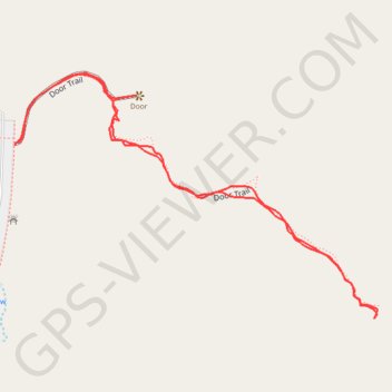
Door Trail in Badlands National Park
The Door Trail is a short but exciting adventure that immerses you into the park’s rugged, lunar-like terrain. After the easy walk on a boardwalk, the trail becomes more uneven, winding through eroded gullies and fascinating rock formations, rewarding you with stunning panoramic views of the Badlands' otherworldly landscape. It’s well worth going beyond the boardwalk to fully appreciate the raw beauty of the park. #Hiking #Rock #Nature
- Distance: 0.8 mi
- Elevation gain: 52 ft
- Maximum elevation: 2,635 ft
- Elevation loss: 52 ft
- Minimum elevation: 2,579 ft
- Moving time: 22 m
- Moving speed: 2.3 mph
- Maximum speed: 3.8 mph
- Total time: 23 m 23 s
- Global speed: 2.2 mph
Interactive trail map
Make a donation
Gear up for your next adventure:
As an Amazon Associate, this site earns from qualifying purchases at no extra cost to you.
Trail profile
- Distance: 0.8 mi
- Elevation gain: 52 ft
- Maximum elevation: 2,635 ft
- Elevation loss: 52 ft
- Minimum elevation: 2,579 ft
- Moving time: 22 m
- Moving speed: 2.3 mph
- Maximum speed: 3.8 mph
- Total time: 23 m 23 s
- Global speed: 2.2 mph
Make a donation
Gear up for your next adventure:
As an Amazon Associate, this site earns from qualifying purchases at no extra cost to you.
About this trail
Name: Door Trail in Badlands National Park trail, distance, elevation, map, profile, GPS track
Start: Door Trail, Jackson County, South Dakota, 57750, United States (43.76355 -101.92669)
End: Door Trail, Jackson County, South Dakota, 57750, United States (43.76357 -101.92663)
Coordinates: 43.76171 -101.92669 43.76431 -101.92137
Topography: Jackson County topographic map, elevation, terrain
Make a donation
Gear up for your next adventure:
As an Amazon Associate, this site earns from qualifying purchases at no extra cost to you.