Thank you for supporting this site ❤️
Make a donation
Make a donation
Gear up for your next adventure:
As an Amazon Associate, this site earns from qualifying purchases at no extra cost to you.
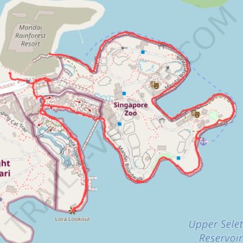
Mandai Boardwalk
- Distance: 2.8 mi
- Elevation gain: 92 ft
- Maximum elevation: 141 ft
- Elevation loss: 112 ft
- Minimum elevation: 89 ft
- Moving time: 1 h 10 m
- Moving speed: 2.3 mph
- Maximum speed: 7.2 mph
- Total time: 1 h 23 m
- Global speed: 2.0 mph
Interactive trail map
Thank you for supporting this site ❤️
Make a donation
Make a donation
Gear up for your next adventure:
As an Amazon Associate, this site earns from qualifying purchases at no extra cost to you.
Trail profile
- Distance: 2.8 mi
- Elevation gain: 92 ft
- Maximum elevation: 141 ft
- Elevation loss: 112 ft
- Minimum elevation: 89 ft
- Moving time: 1 h 10 m
- Moving speed: 2.3 mph
- Maximum speed: 7.2 mph
- Total time: 1 h 23 m
- Global speed: 2.0 mph
Thank you for supporting this site ❤️
Make a donation
Make a donation
Gear up for your next adventure:
As an Amazon Associate, this site earns from qualifying purchases at no extra cost to you.
About this trail
Name: Mandai Boardwalk trail, distance, elevation, map, profile, GPS track
Coordinates: 1.39983 103.78944 1.40662 103.79796
Thank you for supporting this site ❤️
Make a donation
Make a donation
Gear up for your next adventure:
As an Amazon Associate, this site earns from qualifying purchases at no extra cost to you.
Other hiking, mountain biking, running and outdoor activity trails
Click on a trail to view its statistics, map and profile.
The Green Corridor - Singapore
Distance: 13.8 mi • Elevation gain: 548 ft • Maximum elevation: 144 ft
Directions from Duck Tour Ramp to Marina Boulevard, Singapore
Distance: 65.5 mi • Elevation gain: 2,664 ft • Maximum elevation: 167 ft