Thank you for supporting this site ❤️
Make a donation
Make a donation
Gear up for your next adventure:
As an Amazon Associate, this site earns from qualifying purchases at no extra cost to you.
Brandt Pine Trails
- Distance: 9.7 mi
- Elevation gain: 138 ft
- Maximum elevation: 942 ft
- Elevation loss: 138 ft
- Minimum elevation: 912 ft
- Moving time: 1 h 15 m
- Moving speed: 7.7 mph
- Maximum speed: 25.4 mph
- Total time: 1 h 32 m
- Global speed: 6.3 mph
Interactive trail map
Thank you for supporting this site ❤️
Make a donation
Make a donation
Gear up for your next adventure:
As an Amazon Associate, this site earns from qualifying purchases at no extra cost to you.
Trail profile
- Distance: 9.7 mi
- Elevation gain: 138 ft
- Maximum elevation: 942 ft
- Elevation loss: 138 ft
- Minimum elevation: 912 ft
- Moving time: 1 h 15 m
- Moving speed: 7.7 mph
- Maximum speed: 25.4 mph
- Total time: 1 h 32 m
- Global speed: 6.3 mph
Thank you for supporting this site ❤️
Make a donation
Make a donation
Gear up for your next adventure:
As an Amazon Associate, this site earns from qualifying purchases at no extra cost to you.
About this trail
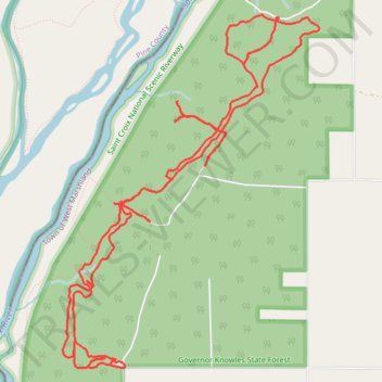
Name: Brandt Pine Trails trail, distance, elevation, map, profile, GPS track
Coordinates: 45.86012 -92.72963 45.88734 -92.70122
Topography: Town of West Marshland topographic map, elevation, terrain
Thank you for supporting this site ❤️
Make a donation
Make a donation
Gear up for your next adventure:
As an Amazon Associate, this site earns from qualifying purchases at no extra cost to you.