Thank you for supporting this site ❤️
Make a donation
Make a donation
Gear up for your next adventure:
As an Amazon Associate, this site earns from qualifying purchases at no extra cost to you.
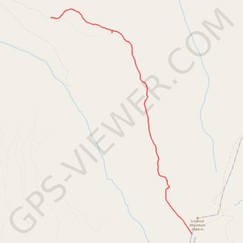
Sunshine Flat Trail #369
- Distance: 3.9 mi
- Elevation gain: 82 ft
- Maximum elevation: 7,818 ft
- Elevation loss: 1,506 ft
- Minimum elevation: 6,388 ft
- Moving time: 1 h 36 m
- Moving speed: 2.4 mph
- Maximum speed: 3.6 mph
- Total time: 2 h 3 m
- Global speed: 1.9 mph
Interactive trail map
Thank you for supporting this site ❤️
Make a donation
Make a donation
Gear up for your next adventure:
As an Amazon Associate, this site earns from qualifying purchases at no extra cost to you.
Trail profile
- Distance: 3.9 mi
- Elevation gain: 82 ft
- Maximum elevation: 7,818 ft
- Elevation loss: 1,506 ft
- Minimum elevation: 6,388 ft
- Moving time: 1 h 36 m
- Moving speed: 2.4 mph
- Maximum speed: 3.6 mph
- Total time: 2 h 3 m
- Global speed: 1.9 mph
Thank you for supporting this site ❤️
Make a donation
Make a donation
Gear up for your next adventure:
As an Amazon Associate, this site earns from qualifying purchases at no extra cost to you.
About this trail
Name: Sunshine Flat Trail #369 trail, distance, elevation, map, profile, GPS track
Start: Forest Road 548, Grant County, Oregon, United States (44.28585 -118.49662)
End: Forest Road 918, Grant County, Oregon, 97869, United States (44.32408 -118.53136)
Coordinates: 44.28584 -118.53136 44.32561 -118.49654
Topography: Grant County topographic map, elevation, terrain
Thank you for supporting this site ❤️
Make a donation
Make a donation
Gear up for your next adventure:
As an Amazon Associate, this site earns from qualifying purchases at no extra cost to you.