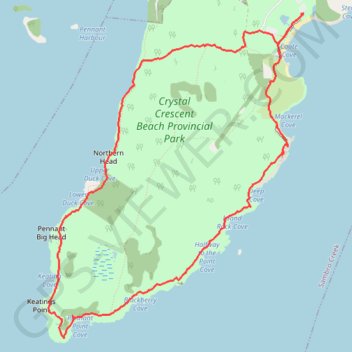
Pennant Point Loop Hike
Crystal Crescent Beach Provincial Park
- Distance: 6.7 mi
- Elevation gain: 440 ft
- Maximum elevation: 102 ft
- Elevation loss: 433 ft
- Minimum elevation: 0 ft
- Moving time: 3 h 1 m
- Moving speed: 2.2 mph
- Maximum speed: 5.2 mph
- Total time: 3 h 21 m
- Global speed: 2.0 mph
Interactive trail map
Trail profile
- Distance: 6.7 mi
- Elevation gain: 440 ft
- Maximum elevation: 102 ft
- Elevation loss: 433 ft
- Minimum elevation: 0 ft
- Moving time: 3 h 1 m
- Moving speed: 2.2 mph
- Maximum speed: 5.2 mph
- Total time: 3 h 21 m
- Global speed: 2.0 mph
About this trail
Name: Pennant Point Loop Hike trail, distance, elevation, map, profile, GPS track
Coordinates: 44.43288 -63.64945 44.46151 -63.61803