Make a donation
Gear up for your next adventure:
As an Amazon Associate, this site earns from qualifying purchases at no extra cost to you.
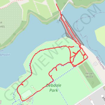
Debdale Park
- Distance: 1.3 mi
- Elevation gain: 89 ft
- Maximum elevation: 289 ft
- Elevation loss: 59 ft
- Minimum elevation: 246 ft
- Moving time: 32 m 22 s
- Moving speed: 2.4 mph
- Maximum speed: 4.2 mph
- Total time: 38 m 21 s
- Global speed: 2.0 mph
Interactive trail map
Make a donation
Gear up for your next adventure:
As an Amazon Associate, this site earns from qualifying purchases at no extra cost to you.
Trail profile
- Distance: 1.3 mi
- Elevation gain: 89 ft
- Maximum elevation: 289 ft
- Elevation loss: 59 ft
- Minimum elevation: 246 ft
- Moving time: 32 m 22 s
- Moving speed: 2.4 mph
- Maximum speed: 4.2 mph
- Total time: 38 m 21 s
- Global speed: 2.0 mph
Make a donation
Gear up for your next adventure:
As an Amazon Associate, this site earns from qualifying purchases at no extra cost to you.
About this trail
Name: Debdale Park trail, distance, elevation, map, profile, GPS track
Coordinates: 53.45957 -2.15735 53.46400 -2.15194
Make a donation
Gear up for your next adventure:
As an Amazon Associate, this site earns from qualifying purchases at no extra cost to you.
Other hiking, mountain biking, running and outdoor activity trails
Click on a trail to view its statistics, map and profile.
Morning Run
United Kingdom > England > Manchester
Distance: 6.5 mi • Elevation gain: 177 ft • Maximum elevation: 325 ft
Gorton Loop
United Kingdom > England > Manchester
Distance: 6.1 mi • Elevation gain: 174 ft • Maximum elevation: 328 ft
Gorton Lower Reservoir Loop
United Kingdom > England > Manchester
Distance: 1.3 mi • Elevation gain: 69 ft • Maximum elevation: 285 ft
Southern shoreline path of Gorton Lower Reservoir
United Kingdom > England > Manchester
Distance: 0.6 mi • Elevation gain: 52 ft • Maximum elevation: 269 ft
Make a donation
Gear up for your next adventure:
As an Amazon Associate, this site earns from qualifying purchases at no extra cost to you.
Wright Robinson Loop
United Kingdom > England > Manchester
Distance: 1.2 mi • Elevation gain: 46 ft • Maximum elevation: 299 ft