Make a donation
Gear up for your next adventure:
As an Amazon Associate, this site earns from qualifying purchases at no extra cost to you.
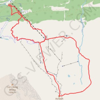
Munro Hillwalk Aonach Mor
Munro, hillwalk, Aonach, Mor
- Distance: 10.8 mi
- Elevation gain: 4,190 ft
- Maximum elevation: 3,999 ft
- Elevation loss: 4,206 ft
- Minimum elevation: 331 ft
- Moving time: 5 h 57 m
- Moving speed: 1.8 mph
- Maximum speed: 5.2 mph
- Total time: 6 h 27 m
- Global speed: 1.7 mph
Interactive trail map
Make a donation
Gear up for your next adventure:
As an Amazon Associate, this site earns from qualifying purchases at no extra cost to you.
Trail profile
- Distance: 10.8 mi
- Elevation gain: 4,190 ft
- Maximum elevation: 3,999 ft
- Elevation loss: 4,206 ft
- Minimum elevation: 331 ft
- Moving time: 5 h 57 m
- Moving speed: 1.8 mph
- Maximum speed: 5.2 mph
- Total time: 6 h 27 m
- Global speed: 1.7 mph
Make a donation
Gear up for your next adventure:
As an Amazon Associate, this site earns from qualifying purchases at no extra cost to you.
About this trail
Name: Munro Hillwalk Aonach Mor trail, distance, elevation, map, profile, GPS track
Start: The Wiggle, Highland, Scotland, PH33 6SQ, United Kingdom (56.85083 -4.99910)
Coordinates: 56.81294 -5.00005 56.85121 -4.93751
Make a donation
Gear up for your next adventure:
As an Amazon Associate, this site earns from qualifying purchases at no extra cost to you.
Other hiking, mountain biking, running and outdoor activity trails
Click on a trail to view its statistics, map and profile.
Great Glen Way (Fort William to Fort Augustus)
United Kingdom > Scotland > Highland > Fort William
Distance: 32.7 mi • Elevation gain: 1,962 ft • Maximum elevation: 354 ft