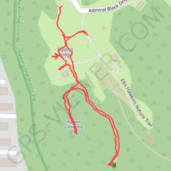
Rippon Lodge Historic Site
- Distance: 0.8 mi
- Elevation gain: 52 ft
- Maximum elevation: 118 ft
- Elevation loss: 49 ft
- Minimum elevation: 82 ft
- Moving time: 15 m 17 s
- Moving speed: 3.0 mph
- Maximum speed: 4.1 mph
- Total time: 18 m 6 s
- Global speed: 2.5 mph
Interactive trail map
Trail profile
- Distance: 0.8 mi
- Elevation gain: 52 ft
- Maximum elevation: 118 ft
- Elevation loss: 49 ft
- Minimum elevation: 82 ft
- Moving time: 15 m 17 s
- Moving speed: 3.0 mph
- Maximum speed: 4.1 mph
- Total time: 18 m 6 s
- Global speed: 2.5 mph
About this trail
Name: Rippon Lodge Historic Site trail, distance, elevation, map, profile, GPS track
Coordinates: 38.61243 -77.27855 38.61551 -77.27687
Topography: Prince William County topographic map, elevation, terrain