Make a donation
Gear up for your next adventure:
As an Amazon Associate, this site earns from qualifying purchases at no extra cost to you.
Abersham Regional Park
Davidson County Trail Run
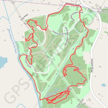
- Distance: 6.1 mi
- Elevation gain: 469 ft
- Maximum elevation: 830 ft
- Elevation loss: 469 ft
- Minimum elevation: 663 ft
- Moving time: 1 h 44 m
- Moving speed: 3.5 mph
- Maximum speed: 7.1 mph
- Total time: 1 h 46 m
- Global speed: 3.4 mph
Interactive trail map
Make a donation
Gear up for your next adventure:
As an Amazon Associate, this site earns from qualifying purchases at no extra cost to you.
Trail profile
- Distance: 6.1 mi
- Elevation gain: 469 ft
- Maximum elevation: 830 ft
- Elevation loss: 469 ft
- Minimum elevation: 663 ft
- Moving time: 1 h 44 m
- Moving speed: 3.5 mph
- Maximum speed: 7.1 mph
- Total time: 1 h 46 m
- Global speed: 3.4 mph
Make a donation
Gear up for your next adventure:
As an Amazon Associate, this site earns from qualifying purchases at no extra cost to you.
About this trail
Name: Abersham Regional Park trail, distance, elevation, map, profile, GPS track
Start: Pleasant Garden Drive, Mecklenburg County, North Carolina, 28036, United States (35.50659 -80.79766)
End: Pleasant Garden Drive, Mecklenburg County, North Carolina, 28036, United States (35.50662 -80.79782)
Coordinates: 35.49302 -80.80880 35.50753 -80.79655
Topography: Mecklenburg County topographic map, elevation, terrain
Make a donation
Gear up for your next adventure:
As an Amazon Associate, this site earns from qualifying purchases at no extra cost to you.
Other hiking, mountain biking, running and outdoor activity trails
Click on a trail to view its statistics, map and profile.
Abersham Regional Park Loop Run
United States > North Carolina > Mecklenburg County
Mecklenburg County Trail Run
Distance: 6.5 mi • Elevation gain: 620 ft • Maximum elevation: 781 ft
Abersham Regional Park Trail Run
United States > North Carolina > Mecklenburg County
Distance: 4.5 mi • Elevation gain: 495 ft • Maximum elevation: 778 ft
Mecklenburg County Trail Run
United States > North Carolina > Mecklenburg County
Distance: 4.4 mi • Elevation gain: 331 ft • Maximum elevation: 784 ft
Abersham Park
United States > North Carolina > Mecklenburg County
Distance: 4.4 mi • Elevation gain: 344 ft • Maximum elevation: 758 ft
Make a donation
Gear up for your next adventure:
As an Amazon Associate, this site earns from qualifying purchases at no extra cost to you.