Thank you for supporting this site ❤️
Make a donation
Make a donation
Gear up for your next adventure:
As an Amazon Associate, this site earns from qualifying purchases at no extra cost to you.
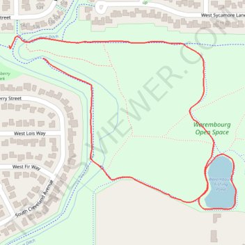
Warembourg Open Space fishing pond loop
- Distance: 1.0 mi
- Elevation gain: 46 ft
- Maximum elevation: 5,436 ft
- Elevation loss: 39 ft
- Minimum elevation: 5,387 ft
- Moving time: 17 m 35 s
- Moving speed: 3.6 mph
- Maximum speed: 4.0 mph
- Total time: 17 m 35 s
- Global speed: 3.6 mph
Interactive trail map
Thank you for supporting this site ❤️
Make a donation
Make a donation
Gear up for your next adventure:
As an Amazon Associate, this site earns from qualifying purchases at no extra cost to you.
Trail profile
- Distance: 1.0 mi
- Elevation gain: 46 ft
- Maximum elevation: 5,436 ft
- Elevation loss: 39 ft
- Minimum elevation: 5,387 ft
- Moving time: 17 m 35 s
- Moving speed: 3.6 mph
- Maximum speed: 4.0 mph
- Total time: 17 m 35 s
- Global speed: 3.6 mph
Thank you for supporting this site ❤️
Make a donation
Make a donation
Gear up for your next adventure:
As an Amazon Associate, this site earns from qualifying purchases at no extra cost to you.
About this trail
Name: Warembourg Open Space fishing pond loop trail, distance, elevation, map, profile, GPS track
Coordinates: 39.96914 -105.14903 39.97248 -105.14332
Topography: Boulder County topographic map, elevation, terrain
Thank you for supporting this site ❤️
Make a donation
Make a donation
Gear up for your next adventure:
As an Amazon Associate, this site earns from qualifying purchases at no extra cost to you.