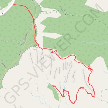
Queen Victoria via Queen's Garden Trail in Bryce Canyon National Park
The Queen's Garden Trail in Bryce Canyon National Park offers hikers a journey through a landscape adorned with unique rock formations, including the Queen Victoria hoodoo, which resembles a regal figure. The path meanders through a natural amphitheater, providing expansive views of the park's distinctive hoodoos and spires. The trail is well-maintained, featuring gentle descents and ascents, making it accessible for most hikers. #Hiking #Rock #Nature
- Distance: 2.0 mi
- Elevation gain: 430 ft
- Maximum elevation: 7,982 ft
- Elevation loss: 430 ft
- Minimum elevation: 7,598 ft
- Moving time: 55 m 27 s
- Moving speed: 2.2 mph
- Maximum speed: 3.6 mph
- Total time: 1 h 15 m
- Global speed: 1.6 mph
Interactive trail map
Trail profile
- Distance: 2.0 mi
- Elevation gain: 430 ft
- Maximum elevation: 7,982 ft
- Elevation loss: 430 ft
- Minimum elevation: 7,598 ft
- Moving time: 55 m 27 s
- Moving speed: 2.2 mph
- Maximum speed: 3.6 mph
- Total time: 1 h 15 m
- Global speed: 1.6 mph
About this trail
Name: Queen Victoria via Queen's Garden Trail in Bryce Canyon National Park trail, distance, elevation, map, profile, GPS track
Coordinates: 37.62498 -112.16452 37.63049 -112.15885
Topography: Garfield County topographic map, elevation, terrain
Other hiking, mountain biking, running and outdoor activity trails
Click on a trail to view its statistics, map and profile.
Sunset Point and Sunrise Point via Rim Trail in Bryce Canyon National Park
United States > Utah > Garfield County
The hike from Sunset Point to Sunrise Point via the Rim Trail in Bryce Canyon National Park offers a breathtaking panoramic view of the park's iconic hoodoos, towering spires of rock formed by erosion. Along the trail, hikers can observe the contrast between the warm, reddish-orange hues of the rocks at sunset…
Distance: 1.2 mi • Elevation gain: 164 ft • Maximum elevation: 8,009 ft
Figure-8 Combination Loop (Bryce Canyon)
United States > Utah > Garfield County
From Sunset Point, the route first follows the rim toward Sunrise Point, opening broad views over the Bryce Amphitheater before dropping into Queen’s Garden, where pale orange hoodoos, sculpted walls, and fir-dotted slopes gradually surround the trail. The descent leads from the overlook atmosphere of the…
Distance: 6.4 mi • Elevation gain: 1,640 ft • Maximum elevation: 7,976 ft
Wall Street, Navajo Loop and Queens Garden Loop Trail in Bryce Canyon National Park
United States > Utah > Garfield County
This loop trail offers a captivating journey through stunning red rock formations, where every turn reveals breathtaking views that leave you in awe. This well-maintained path, with its mix of shaded areas and open vistas, makes for a memorable hike that showcases the park's unique beauty while challenging you…
Distance: 3.2 mi • Elevation gain: 715 ft • Maximum elevation: 8,018 ft
Queen Victoria Loop via Queen's Garden Trail and Navajo Trail
United States > Utah > Garfield County
The Queen Victoria Loop offers a captivating journey through Bryce Canyon's iconic landscape. Hikers will encounter dramatic hoodoos, including the famous Queen Victoria formation, as well as narrow canyons and archways along the route. The path provides stunning views of the Bryce Amphitheater, and as you…
Distance: 3.2 mi • Elevation gain: 673 ft • Maximum elevation: 8,018 ft
Bryce Canyon National Park Peek-a-Boo Loop
United States > Utah > Garfield County
BCNP
Distance: 15.9 mi • Elevation gain: 2,740 ft • Maximum elevation: 8,330 ft
Bryce NP
United States > Utah > Garfield County
Distance: 3.0 mi • Elevation gain: 709 ft • Maximum elevation: 8,018 ft