Make a donation
Gear up for your next adventure:
As an Amazon Associate, this site earns from qualifying purchases at no extra cost to you.
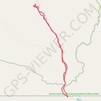
Wahweap Hoodoos Trail
Hike along the Wahweap Creek via the Nipple Canyon Road and the Wahweap Hoodoos Trail in the Grand Staircase-Escalante National Monument and the Wahweap Wilderness Study Area. #Hiking #Nature #River #Wilderness
- Distance: 9.4 mi
- Elevation gain: 515 ft
- Maximum elevation: 4,308 ft
- Elevation loss: 541 ft
- Minimum elevation: 4,016 ft
- Moving time: 4 h 44 m
- Moving speed: 2.0 mph
- Maximum speed: 2.8 mph
- Total time: 5 h 50 m
- Global speed: 1.6 mph
Interactive trail map
Make a donation
Gear up for your next adventure:
As an Amazon Associate, this site earns from qualifying purchases at no extra cost to you.
Trail profile
- Distance: 9.4 mi
- Elevation gain: 515 ft
- Maximum elevation: 4,308 ft
- Elevation loss: 541 ft
- Minimum elevation: 4,016 ft
- Moving time: 4 h 44 m
- Moving speed: 2.0 mph
- Maximum speed: 2.8 mph
- Total time: 5 h 50 m
- Global speed: 1.6 mph
Make a donation
Gear up for your next adventure:
As an Amazon Associate, this site earns from qualifying purchases at no extra cost to you.
About this trail
Name: Wahweap Hoodoos Trail trail, distance, elevation, map, profile, GPS track
Start: Nipple Creek Road, Kane County, Utah, United States (37.10600 -111.68713)
End: Nipple Creek Road, Kane County, Utah, United States (37.10643 -111.68722)
Coordinates: 37.10600 -111.71310 37.16225 -111.68713
Topography: Kane County topographic map, elevation, terrain
Make a donation
Gear up for your next adventure:
As an Amazon Associate, this site earns from qualifying purchases at no extra cost to you.