Thank you for supporting this site ❤️
Make a donation
Make a donation
Gear up for your next adventure:
As an Amazon Associate, this site earns from qualifying purchases at no extra cost to you.
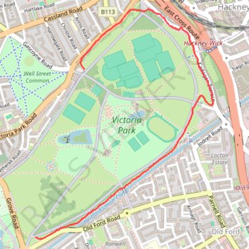
Running Victoria Park
- Distance: 1.5 mi
- Elevation gain: 30 ft
- Maximum elevation: 59 ft
- Elevation loss: 33 ft
- Minimum elevation: 36 ft
- Moving time: 13 m 54 s
- Moving speed: 6.5 mph
- Maximum speed: 10.3 mph
- Total time: 15 m 1 s
- Global speed: 6.0 mph
Interactive trail map
Thank you for supporting this site ❤️
Make a donation
Make a donation
Gear up for your next adventure:
As an Amazon Associate, this site earns from qualifying purchases at no extra cost to you.
Trail profile
- Distance: 1.5 mi
- Elevation gain: 30 ft
- Maximum elevation: 59 ft
- Elevation loss: 33 ft
- Minimum elevation: 36 ft
- Moving time: 13 m 54 s
- Moving speed: 6.5 mph
- Maximum speed: 10.3 mph
- Total time: 15 m 1 s
- Global speed: 6.0 mph
Thank you for supporting this site ❤️
Make a donation
Make a donation
Gear up for your next adventure:
As an Amazon Associate, this site earns from qualifying purchases at no extra cost to you.
About this trail
Name: Running Victoria Park trail, distance, elevation, map, profile, GPS track
Coordinates: 51.53374 -0.04074 51.54422 -0.02773
Thank you for supporting this site ❤️
Make a donation
Make a donation
Gear up for your next adventure:
As an Amazon Associate, this site earns from qualifying purchases at no extra cost to you.
Other hiking, mountain biking, running and outdoor activity trails
Click on a trail to view its statistics, map and profile.
Northern Section of Green Link Walk from Epping Forest to Smithfield Market
United Kingdom > England > London
Distance: 10.9 mi • Elevation gain: 233 ft • Maximum elevation: 151 ft