Thank you for supporting this site ❤️
Make a donation
Make a donation
Gear up for your next adventure:
As an Amazon Associate, this site earns from qualifying purchases at no extra cost to you.
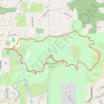
Hartwood Acres Loop Trails
- Distance: 4.0 mi
- Elevation gain: 479 ft
- Maximum elevation: 1,302 ft
- Elevation loss: 486 ft
- Minimum elevation: 1,076 ft
- Moving time: 1 h 24 m
- Moving speed: 2.8 mph
- Maximum speed: 6.5 mph
- Total time: 1 h 25 m
- Global speed: 2.8 mph
Interactive trail map
Thank you for supporting this site ❤️
Make a donation
Make a donation
Gear up for your next adventure:
As an Amazon Associate, this site earns from qualifying purchases at no extra cost to you.
Trail profile
- Distance: 4.0 mi
- Elevation gain: 479 ft
- Maximum elevation: 1,302 ft
- Elevation loss: 486 ft
- Minimum elevation: 1,076 ft
- Moving time: 1 h 24 m
- Moving speed: 2.8 mph
- Maximum speed: 6.5 mph
- Total time: 1 h 25 m
- Global speed: 2.8 mph
Thank you for supporting this site ❤️
Make a donation
Make a donation
Gear up for your next adventure:
As an Amazon Associate, this site earns from qualifying purchases at no extra cost to you.
About this trail
Name: Hartwood Acres Loop Trails trail, distance, elevation, map, profile, GPS track
Coordinates: 40.56573 -79.92715 40.57388 -79.90291
Topography: Allegheny County topographic map, elevation, terrain
Thank you for supporting this site ❤️
Make a donation
Make a donation
Gear up for your next adventure:
As an Amazon Associate, this site earns from qualifying purchases at no extra cost to you.