Thank you for supporting this site ❤️
Make a donation
Make a donation
Gear up for your next adventure:
As an Amazon Associate, this site earns from qualifying purchases at no extra cost to you.
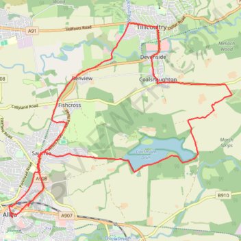
Bike ride around Coalsnaughton via Tillicoultry, Alloa and Gartmorn Dam
- Distance: 11.3 mi
- Elevation gain: 561 ft
- Maximum elevation: 335 ft
- Elevation loss: 561 ft
- Minimum elevation: 43 ft
- Moving time: 1 h 12 m
- Moving speed: 9.4 mph
- Maximum speed: 27.3 mph
- Total time: 2 h 26 m
- Global speed: 4.6 mph
Interactive trail map
Thank you for supporting this site ❤️
Make a donation
Make a donation
Gear up for your next adventure:
As an Amazon Associate, this site earns from qualifying purchases at no extra cost to you.
Trail profile
- Distance: 11.3 mi
- Elevation gain: 561 ft
- Maximum elevation: 335 ft
- Elevation loss: 561 ft
- Minimum elevation: 43 ft
- Moving time: 1 h 12 m
- Moving speed: 9.4 mph
- Maximum speed: 27.3 mph
- Total time: 2 h 26 m
- Global speed: 4.6 mph
Thank you for supporting this site ❤️
Make a donation
Make a donation
Gear up for your next adventure:
As an Amazon Associate, this site earns from qualifying purchases at no extra cost to you.
About this trail
Name: Bike ride around Coalsnaughton via Tillicoultry, Alloa and Gartmorn Dam trail, distance, elevation, map, profile, GPS track
Coordinates: 56.11499 -3.79253 56.15386 -3.71271
Thank you for supporting this site ❤️
Make a donation
Make a donation
Gear up for your next adventure:
As an Amazon Associate, this site earns from qualifying purchases at no extra cost to you.