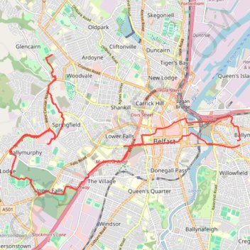
Forth Meadows Greenway, Belfast
Cycling
- Distance: 15.8 mi
- Elevation gain: 764 ft
- Maximum elevation: 256 ft
- Elevation loss: 768 ft
- Minimum elevation: 7 ft
- Moving time: 1 h 36 m
- Moving speed: 9.8 mph
- Maximum speed: 22.7 mph
- Total time: 1 h 56 m
- Global speed: 8.1 mph
Interactive trail map
Trail profile
- Distance: 15.8 mi
- Elevation gain: 764 ft
- Maximum elevation: 256 ft
- Elevation loss: 768 ft
- Minimum elevation: 7 ft
- Moving time: 1 h 36 m
- Moving speed: 9.8 mph
- Maximum speed: 22.7 mph
- Total time: 1 h 56 m
- Global speed: 8.1 mph
About this trail
Name: Forth Meadows Greenway, Belfast trail, distance, elevation, map, profile, GPS track
Coordinates: 54.58472 -5.98783 54.61513 -5.90183
Other hiking, mountain biking, running and outdoor activity trails
Click on a trail to view its statistics, map and profile.
CTS-N.Irelandv1.1-Belfast-Titanic>Enniscrone-via antrim coast-209miles
United Kingdom > Northern Ireland > County Down > Belfast
Distance: 208.7 mi • Elevation gain: 13,074 ft • Maximum elevation: 889 ft
Cycle up Divis and Black Mountain
United Kingdom > Northern Ireland > County Down > Belfast
Divis, Black Mountain, Cycle, Bicycle
Distance: 16.6 mi • Elevation gain: 1,398 ft • Maximum elevation: 1,257 ft
Belfast to Dungannon
United Kingdom > Northern Ireland > County Antrim > Belfast
Bicycle ride from Belfast Big Fish to Dungannon.
Distance: 51.7 mi • Elevation gain: 1,801 ft • Maximum elevation: 246 ft
Scrabo Loop
United Kingdom > Northern Ireland > County Down > Belfast
Cycling belfast, newtownards, comber, dundonald, holywood, bicycle
Distance: 25.8 mi • Elevation gain: 1,316 ft • Maximum elevation: 512 ft
Lagan & Lough
United Kingdom > Northern Ireland > County Antrim > Tullynacross
Distance: 18.3 mi • Elevation gain: 502 ft • Maximum elevation: 115 ft