Make a donation
Gear up for your next adventure:
As an Amazon Associate, this site earns from qualifying purchases at no extra cost to you.
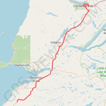
Robinson's Junction - Corner Brook
- Distance: 69.1 mi
- Elevation gain: 3,793 ft
- Maximum elevation: 1,030 ft
- Elevation loss: 4,052 ft
- Minimum elevation: 0 ft
Interactive trail map
Make a donation
Gear up for your next adventure:
As an Amazon Associate, this site earns from qualifying purchases at no extra cost to you.
Trail profile
- Distance: 69.1 mi
- Elevation gain: 3,793 ft
- Maximum elevation: 1,030 ft
- Elevation loss: 4,052 ft
- Minimum elevation: 0 ft
Make a donation
Gear up for your next adventure:
As an Amazon Associate, this site earns from qualifying purchases at no extra cost to you.
About this trail
Name: Robinson's Junction - Corner Brook trail, distance, elevation, map, profile, GPS track
Start: Trans Canada Highway, Newfoundland, Newfoundland and Labrador, Canada (48.28876 -58.63520)
Coordinates: 48.28876 -58.63520 48.96578 -57.88637
Make a donation
Gear up for your next adventure:
As an Amazon Associate, this site earns from qualifying purchases at no extra cost to you.
Other hiking, mountain biking, running and outdoor activity trails
Click on a trail to view its statistics, map and profile.
Corner Brook - Deer Lake
Canada > Newfoundland and Labrador > Corner Brook
#Bike #CornerBrook #Deer #Newfoundland
Distance: 39.9 mi • Elevation gain: 1,463 ft • Maximum elevation: 449 ft