Make a donation
Gear up for your next adventure:
As an Amazon Associate, this site earns from qualifying purchases at no extra cost to you.
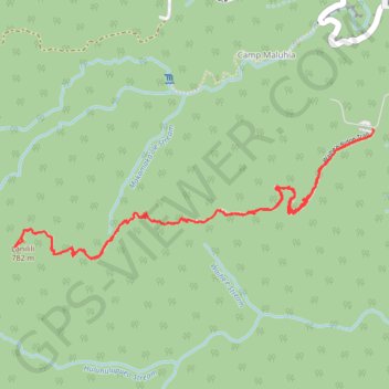
Waihe'e Ridge and Lanilili (Maui Island)
Hike to Waihe'e Ridge and Lanilili via Waihe'e Ridge Trail on Maui Island. #Hiking #Mountain #Volcano #Nature #Forest #Island #Hawaii #Sea #Pacific #Ocean
- Distance: 4.3 mi
- Elevation gain: 1,522 ft
- Maximum elevation: 2,513 ft
- Elevation loss: 1,539 ft
- Minimum elevation: 1,070 ft
- Moving time: 2 h 35 s
- Moving speed: 2.1 mph
- Maximum speed: 25.9 mph
- Total time: 2 h 58 m
- Global speed: 1.5 mph
Interactive trail map
Make a donation
Gear up for your next adventure:
As an Amazon Associate, this site earns from qualifying purchases at no extra cost to you.
Trail profile
- Distance: 4.3 mi
- Elevation gain: 1,522 ft
- Maximum elevation: 2,513 ft
- Elevation loss: 1,539 ft
- Minimum elevation: 1,070 ft
- Moving time: 2 h 35 s
- Moving speed: 2.1 mph
- Maximum speed: 25.9 mph
- Total time: 2 h 58 m
- Global speed: 1.5 mph
Make a donation
Gear up for your next adventure:
As an Amazon Associate, this site earns from qualifying purchases at no extra cost to you.
About this trail
Name: Waihe'e Ridge and Lanilili (Maui Island) trail, distance, elevation, map, profile, GPS track
Start: Waiheʻe Ridge Trail, Camp Maluhia, Maui County, Hawaii, United States (20.95246 -156.53202)
End: Waiheʻe Ridge Trail, Camp Maluhia, Maui County, Hawaii, United States (20.95276 -156.53190)
Coordinates: 20.94613 -156.55166 20.95276 -156.53183
Topography: Maui County topographic map, elevation, terrain
Make a donation
Gear up for your next adventure:
As an Amazon Associate, this site earns from qualifying purchases at no extra cost to you.