Thank you for supporting this site ❤️
Make a donation
Make a donation
Gear up for your next adventure:
As an Amazon Associate, this site earns from qualifying purchases at no extra cost to you.
Little Buller
- Distance: 2.2 mi
- Elevation gain: 318 ft
- Maximum elevation: 5,449 ft
- Elevation loss: 1,119 ft
- Minimum elevation: 4,600 ft
- Moving time: 45 m 36 s
- Moving speed: 2.9 mph
- Maximum speed: 7.9 mph
- Total time: 53 m 14 s
- Global speed: 2.5 mph
Interactive trail map
Thank you for supporting this site ❤️
Make a donation
Make a donation
Gear up for your next adventure:
As an Amazon Associate, this site earns from qualifying purchases at no extra cost to you.
Trail profile
- Distance: 2.2 mi
- Elevation gain: 318 ft
- Maximum elevation: 5,449 ft
- Elevation loss: 1,119 ft
- Minimum elevation: 4,600 ft
- Moving time: 45 m 36 s
- Moving speed: 2.9 mph
- Maximum speed: 7.9 mph
- Total time: 53 m 14 s
- Global speed: 2.5 mph
Thank you for supporting this site ❤️
Make a donation
Make a donation
Gear up for your next adventure:
As an Amazon Associate, this site earns from qualifying purchases at no extra cost to you.
About this trail
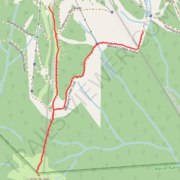
Name: Little Buller trail, distance, elevation, map, profile, GPS track
Coordinates: -37.16464 146.43194 -37.15142 146.44254
Thank you for supporting this site ❤️
Make a donation
Make a donation
Gear up for your next adventure:
As an Amazon Associate, this site earns from qualifying purchases at no extra cost to you.