Make a donation
Gear up for your next adventure:
As an Amazon Associate, this site earns from qualifying purchases at no extra cost to you.
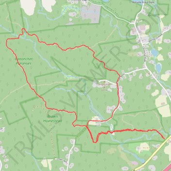
Canonchet Preserves hiking loop trails
- Distance: 5.3 mi
- Elevation gain: 410 ft
- Maximum elevation: 338 ft
- Elevation loss: 410 ft
- Minimum elevation: 102 ft
- Moving time: 2 h 13 m
- Moving speed: 2.4 mph
- Maximum speed: 4.6 mph
- Total time: 2 h 51 m
- Global speed: 1.9 mph
Interactive trail map
Make a donation
Gear up for your next adventure:
As an Amazon Associate, this site earns from qualifying purchases at no extra cost to you.
Trail profile
- Distance: 5.3 mi
- Elevation gain: 410 ft
- Maximum elevation: 338 ft
- Elevation loss: 410 ft
- Minimum elevation: 102 ft
- Moving time: 2 h 13 m
- Moving speed: 2.4 mph
- Maximum speed: 4.6 mph
- Total time: 2 h 51 m
- Global speed: 1.9 mph
Make a donation
Gear up for your next adventure:
As an Amazon Associate, this site earns from qualifying purchases at no extra cost to you.
About this trail
Name: Canonchet Preserves hiking loop trails trail, distance, elevation, map, profile, GPS track
Start: Yellow, Hopkinton, South County, Rhode Island, 02832, United States (41.48216 -71.74751)
End: Yellow, Hopkinton, South County, Rhode Island, 02832, United States (41.48216 -71.74757)
Coordinates: 41.48168 -71.77463 41.49635 -71.74751
Topography: South County topographic map, elevation, terrain
Make a donation
Gear up for your next adventure:
As an Amazon Associate, this site earns from qualifying purchases at no extra cost to you.