Make a donation
Gear up for your next adventure:
As an Amazon Associate, this site earns from qualifying purchases at no extra cost to you.
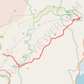
Mesada - Arad
מצדה לערד: קו ארוך לרוחב מדבר יהודה
- Distance: 11.8 mi
- Elevation gain: 3,999 ft
- Maximum elevation: 1,893 ft
- Elevation loss: 1,142 ft
- Minimum elevation: -974 ft
- Moving time: 6 h 17 m
- Moving speed: 1.9 mph
- Maximum speed: 2.6 mph
- Total time: 6 h 17 m
- Global speed: 1.9 mph
Interactive trail map
Make a donation
Gear up for your next adventure:
As an Amazon Associate, this site earns from qualifying purchases at no extra cost to you.
Trail profile
- Distance: 11.8 mi
- Elevation gain: 3,999 ft
- Maximum elevation: 1,893 ft
- Elevation loss: 1,142 ft
- Minimum elevation: -974 ft
- Moving time: 6 h 17 m
- Moving speed: 1.9 mph
- Maximum speed: 2.6 mph
- Total time: 6 h 17 m
- Global speed: 1.9 mph
Make a donation
Gear up for your next adventure:
As an Amazon Associate, this site earns from qualifying purchases at no extra cost to you.
About this trail
Name: Mesada - Arad trail, distance, elevation, map, profile, GPS track
Start: Tamar Regional Council, Beersheba Subdistrict, South District, Israel (31.31244 35.36438)
End: Moab, Arad, Beersheba Subdistrict, South District, Israel (31.26132 35.23943)
Coordinates: 31.24427 35.23939 31.31244 35.36438
Make a donation
Gear up for your next adventure:
As an Amazon Associate, this site earns from qualifying purchases at no extra cost to you.
Other hiking, mountain biking, running and outdoor activity trails
Click on a trail to view its statistics, map and profile.
7 Ascents in the Dead Sea
Israel > South District > Tamar Regional Council
שבע מעלות בים המלח: קו עליות דרך עשאל, משמר, צאלים ומצדה
Distance: 19.4 mi • Elevation gain: 6,929 ft • Maximum elevation: 902 ft