Thank you for supporting this site ❤️
Make a donation
Make a donation
Gear up for your next adventure:
As an Amazon Associate, this site earns from qualifying purchases at no extra cost to you.
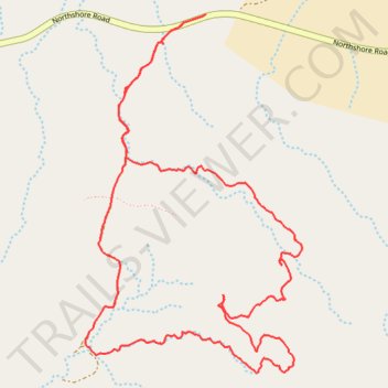
West Redstone Loop Hike
- Distance: 4.8 mi
- Elevation gain: 584 ft
- Maximum elevation: 2,444 ft
- Elevation loss: 584 ft
- Minimum elevation: 2,083 ft
- Moving time: 1 h 58 m
- Moving speed: 2.4 mph
- Maximum speed: 4.0 mph
- Total time: 2 h 3 m
- Global speed: 2.3 mph
Interactive trail map
Thank you for supporting this site ❤️
Make a donation
Make a donation
Gear up for your next adventure:
As an Amazon Associate, this site earns from qualifying purchases at no extra cost to you.
Trail profile
- Distance: 4.8 mi
- Elevation gain: 584 ft
- Maximum elevation: 2,444 ft
- Elevation loss: 584 ft
- Minimum elevation: 2,083 ft
- Moving time: 1 h 58 m
- Moving speed: 2.4 mph
- Maximum speed: 4.0 mph
- Total time: 2 h 3 m
- Global speed: 2.3 mph
Thank you for supporting this site ❤️
Make a donation
Make a donation
Gear up for your next adventure:
As an Amazon Associate, this site earns from qualifying purchases at no extra cost to you.
About this trail
Name: West Redstone Loop Hike trail, distance, elevation, map, profile, GPS track
Start: Northshore Road, Clark County, Nevada, United States (36.24337 -114.53803)
End: Northshore Road, Clark County, Nevada, United States (36.24339 -114.53795)
Coordinates: 36.22659 -114.54495 36.24339 -114.53237
Topography: Clark County topographic map, elevation, terrain
Thank you for supporting this site ❤️
Make a donation
Make a donation
Gear up for your next adventure:
As an Amazon Associate, this site earns from qualifying purchases at no extra cost to you.