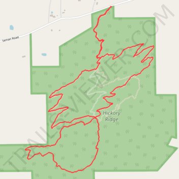
Sanctuary Trail Mountain Bike Ride in Hickory Ridge
- Distance: 5.4 mi
- Elevation gain: 538 ft
- Maximum elevation: 1,870 ft
- Elevation loss: 535 ft
- Minimum elevation: 1,503 ft
- Moving time: 54 m 58 s
- Moving speed: 5.9 mph
- Maximum speed: 22.5 mph
- Total time: 1 h 10 m
- Global speed: 4.6 mph
Interactive trail map
Trail profile
- Distance: 5.4 mi
- Elevation gain: 538 ft
- Maximum elevation: 1,870 ft
- Elevation loss: 535 ft
- Minimum elevation: 1,503 ft
- Moving time: 54 m 58 s
- Moving speed: 5.9 mph
- Maximum speed: 22.5 mph
- Total time: 1 h 10 m
- Global speed: 4.6 mph
About this trail
Name: Sanctuary Trail Mountain Bike Ride in Hickory Ridge trail, distance, elevation, map, profile, GPS track
End: Homestead, Town of Naples, Ontario County, New York, 14512, United States (42.66169 -77.39596)
Coordinates: 42.64702 -77.40630 42.66169 -77.39074
Topography: Ontario County topographic map, elevation, terrain
Other hiking, mountain biking, running and outdoor activity trails
Click on a trail to view its statistics, map and profile.
Sanctuary trail walk in Hickory Ridge
United States > New York > Ontario County > Town of Naples
Distance: 4.3 mi • Elevation gain: 486 ft • Maximum elevation: 1,870 ft