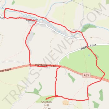
Uploders Shipton Hill Loop Run
- Distance: 5.1 mi
- Elevation gain: 600 ft
- Maximum elevation: 489 ft
- Elevation loss: 600 ft
- Minimum elevation: 82 ft
- Moving time: 50 m 54 s
- Moving speed: 6.0 mph
- Maximum speed: 15.3 mph
- Total time: 51 m 52 s
- Global speed: 5.9 mph
Interactive trail map
Trail profile
- Distance: 5.1 mi
- Elevation gain: 600 ft
- Maximum elevation: 489 ft
- Elevation loss: 600 ft
- Minimum elevation: 82 ft
- Moving time: 50 m 54 s
- Moving speed: 6.0 mph
- Maximum speed: 15.3 mph
- Total time: 51 m 52 s
- Global speed: 5.9 mph
About this trail
Name: Uploders Shipton Hill Loop Run trail, distance, elevation, map, profile, GPS track
Start: New Road, Uploders, Loders, Yondover, Dorset, England, DT6 4NY, United Kingdom (50.73903 -2.70438)
End: New Road, Uploders, Loders, Yondover, Dorset, England, DT6 4NY, United Kingdom (50.73903 -2.70430)
Coordinates: 50.72642 -2.71189 50.74378 -2.68188