Kenosha
Ken-O-Sha Park
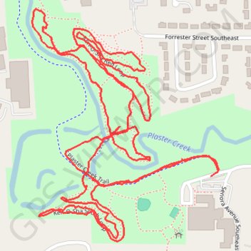
- Distance: 3.0 mi
- Elevation gain: 98 ft
- Maximum elevation: 702 ft
- Elevation loss: 98 ft
- Minimum elevation: 666 ft
- Moving time: 21 m 54 s
- Moving speed: 8.3 mph
- Maximum speed: 23.6 mph
- Total time: 26 m 17 s
- Global speed: 6.9 mph
Interactive trail map
Trail profile
- Distance: 3.0 mi
- Elevation gain: 98 ft
- Maximum elevation: 702 ft
- Elevation loss: 98 ft
- Minimum elevation: 666 ft
- Moving time: 21 m 54 s
- Moving speed: 8.3 mph
- Maximum speed: 23.6 mph
- Total time: 26 m 17 s
- Global speed: 6.9 mph
About this trail
Name: Kenosha trail, distance, elevation, map, profile, GPS track
Coordinates: 42.90371 -85.63873 42.90920 -85.63270
Topography: Grand Rapids topographic map, elevation, terrain