Make a donation
Gear up for your next adventure:
As an Amazon Associate, this site earns from qualifying purchases at no extra cost to you.
Bulle and its surrounding castles – Shortened alternative
Would you like to discover the Châteaux of Bulle and Gruyères by bike ?
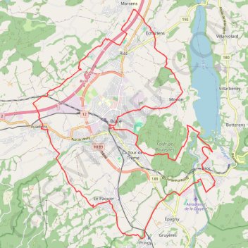
- Distance: 20.1 mi
- Elevation gain: 1,565 ft
- Maximum elevation: 2,867 ft
- Elevation loss: 1,565 ft
- Minimum elevation: 2,234 ft
Interactive trail map
Make a donation
Gear up for your next adventure:
As an Amazon Associate, this site earns from qualifying purchases at no extra cost to you.
Trail profile
- Distance: 20.1 mi
- Elevation gain: 1,565 ft
- Maximum elevation: 2,867 ft
- Elevation loss: 1,565 ft
- Minimum elevation: 2,234 ft
Make a donation
Gear up for your next adventure:
As an Amazon Associate, this site earns from qualifying purchases at no extra cost to you.
About this trail
Name: Bulle and its surrounding castles – Shortened alternative trail, distance, elevation, map, profile, GPS track
Coordinates: 46.58250 7.02049 46.65380 7.10302
Make a donation
Gear up for your next adventure:
As an Amazon Associate, this site earns from qualifying purchases at no extra cost to you.
Other hiking, mountain biking, running and outdoor activity trails
Click on a trail to view its statistics, map and profile.
PT23DS2 Lörrach → Cadaqués
Germany > Baden-Württemberg > Landkreis Lörrach > Lörrach (Kernstadt)
Distance: 652.9 mi • Elevation gain: 43,077 ft • Maximum elevation: 4,938 ft