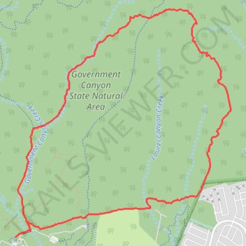
Loop hike via Recharge Trail, Far Reaches Trail and Wildcat Canyon Trail in Government Canyon State Natural Area
- Distance: 7.1 mi
- Elevation gain: 502 ft
- Maximum elevation: 1,362 ft
- Elevation loss: 495 ft
- Minimum elevation: 1,017 ft
- Moving time: 2 h 41 m
- Moving speed: 2.6 mph
- Maximum speed: 3.8 mph
- Total time: 3 h 6 m
- Global speed: 2.3 mph
Interactive trail map
Trail profile
- Distance: 7.1 mi
- Elevation gain: 502 ft
- Maximum elevation: 1,362 ft
- Elevation loss: 495 ft
- Minimum elevation: 1,017 ft
- Moving time: 2 h 41 m
- Moving speed: 2.6 mph
- Maximum speed: 3.8 mph
- Total time: 3 h 6 m
- Global speed: 2.3 mph
About this trail
Name: Loop hike via Recharge Trail, Far Reaches Trail and Wildcat Canyon Trail in Government Canyon State Natural Area trail, distance, elevation, map, profile, GPS track
Start: Interpretive Nature Trail, San Antonio, Bexar County, Texas, United States (29.54945 -98.76443)
End: Interpretive Nature Trail, San Antonio, Bexar County, Texas, United States (29.54927 -98.76475)
Coordinates: 29.54927 -98.76475 29.57740 -98.73419
Topography: San Antonio topographic map, elevation, terrain