Thank you for supporting this site ❤️
Make a donation
Make a donation
Gear up for your next adventure:
As an Amazon Associate, this site earns from qualifying purchases at no extra cost to you.
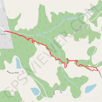
Roquena Trail through the woods near La Honda
- Distance: 1.9 mi
- Elevation gain: 427 ft
- Maximum elevation: 1,178 ft
- Elevation loss: 430 ft
- Minimum elevation: 761 ft
- Moving time: 47 m 7 s
- Moving speed: 2.4 mph
- Maximum speed: 3.6 mph
- Total time: 1 h 9 m
- Global speed: 1.6 mph
Interactive trail map
Thank you for supporting this site ❤️
Make a donation
Make a donation
Gear up for your next adventure:
As an Amazon Associate, this site earns from qualifying purchases at no extra cost to you.
Trail profile
- Distance: 1.9 mi
- Elevation gain: 427 ft
- Maximum elevation: 1,178 ft
- Elevation loss: 430 ft
- Minimum elevation: 761 ft
- Moving time: 47 m 7 s
- Moving speed: 2.4 mph
- Maximum speed: 3.6 mph
- Total time: 1 h 9 m
- Global speed: 1.6 mph
Thank you for supporting this site ❤️
Make a donation
Make a donation
Gear up for your next adventure:
As an Amazon Associate, this site earns from qualifying purchases at no extra cost to you.
About this trail
Name: Roquena Trail through the woods near La Honda trail, distance, elevation, map, profile, GPS track
Coordinates: 37.31871 -122.26232 37.32233 -122.25158
Topography: San Mateo County topographic map, elevation, terrain
Thank you for supporting this site ❤️
Make a donation
Make a donation
Gear up for your next adventure:
As an Amazon Associate, this site earns from qualifying purchases at no extra cost to you.