Tuck Lake and Hyas Lake via Deception Pass Trail and Robin Lakes Trail
The hike to Tuck Lake via the Deception Pass and Robin Lakes Trails is a rewarding but strenuous adventure in the Alpine Lakes Wilderness. Starting with an easy, scenic walk around the tranquil shores of Hyas Lake, the trail quickly ascends through a series of switchbacks, leading hikers to breathtaking alpine vistas. The rugged terrain becomes more challenging as you approach Tuck Lake, but the effort is compensated by stunning views of the surrounding peaks like Mount Daniel, Cathedral Rock and Granite Mountain, making this hike a memorable journey for experienced hikers. #Hiking #Mountain #Forest #Nature #Lake
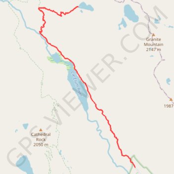
- Distance: 5.1 mi
- Elevation gain: 2,215 ft
- Maximum elevation: 5,318 ft
- Elevation loss: 325 ft
- Minimum elevation: 3,406 ft
Interactive trail map
Trail profile
- Distance: 5.1 mi
- Elevation gain: 2,215 ft
- Maximum elevation: 5,318 ft
- Elevation loss: 325 ft
- Minimum elevation: 3,406 ft
About this trail
Name: Tuck Lake and Hyas Lake via Deception Pass Trail and Robin Lakes Trail trail, distance, elevation, map, profile, GPS track
End: Robin Lakes Trail, Kittitas County, Washington, United States (47.58843 -121.12050)
Coordinates: 47.54497 -121.13641 47.58843 -121.09779
Topography: Kittitas County topographic map, elevation, terrain
Other hiking, mountain biking, running and outdoor activity trails
Click on a trail to view its statistics, map and profile.
Northern part of the Pacific Crest Trail (PCT)
United States > Oregon > Klamath County
Hike on the Pacific Crest National Scenic Trail from Crater Lake to Canada Border through Oregon and Washington along the Sierra Nevada and Cascade mountain ranges. #Hiking #Mountain #SierraNevada #Cascade #Nature #Forest #Park #PCT
Distance: 744.6 mi • Elevation gain: 145,367 ft • Maximum elevation: 7,569 ft