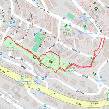
פארק שמואל
- Distance: 0.8 mi
- Elevation gain: 144 ft
- Maximum elevation: 417 ft
- Elevation loss: 141 ft
- Minimum elevation: 272 ft
- Moving time: 21 m 46 s
- Moving speed: 2.2 mph
- Maximum speed: 4.2 mph
- Total time: 23 m 38 s
- Global speed: 2.0 mph
Interactive trail map
Trail profile
- Distance: 0.8 mi
- Elevation gain: 144 ft
- Maximum elevation: 417 ft
- Elevation loss: 141 ft
- Minimum elevation: 272 ft
- Moving time: 21 m 46 s
- Moving speed: 2.2 mph
- Maximum speed: 4.2 mph
- Total time: 23 m 38 s
- Global speed: 2.0 mph
About this trail
Name: פארק שמואל trail, distance, elevation, map, profile, GPS track
Start: 28, Amos, Ben Dor, Nesher, Haifa Subdistrict, Haifa District, 3688520, Israel (32.77482 35.03086)
End: 28, Amos, Ben Dor, Nesher, Haifa Subdistrict, Haifa District, 3688520, Israel (32.77475 35.03087)
Coordinates: 32.77350 35.03086 32.77491 35.03552