Thank you for supporting this site ❤️
Make a donation
Make a donation
Gear up for your next adventure:
As an Amazon Associate, this site earns from qualifying purchases at no extra cost to you.
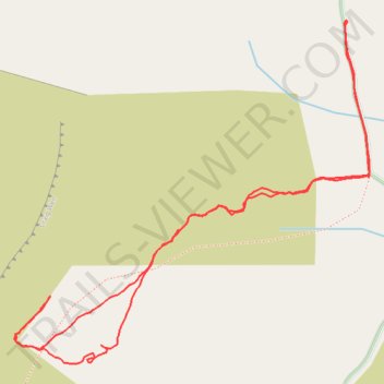
Walk up to Craig Wen and the manganese mine
- Distance: 1.8 mi
- Elevation gain: 620 ft
- Maximum elevation: 1,368 ft
- Elevation loss: 620 ft
- Minimum elevation: 778 ft
- Moving time: 1 h 14 m
- Moving speed: 1.5 mph
- Maximum speed: 3.4 mph
- Total time: 1 h 35 m
- Global speed: 1.2 mph
Interactive trail map
Thank you for supporting this site ❤️
Make a donation
Make a donation
Gear up for your next adventure:
As an Amazon Associate, this site earns from qualifying purchases at no extra cost to you.
Trail profile
- Distance: 1.8 mi
- Elevation gain: 620 ft
- Maximum elevation: 1,368 ft
- Elevation loss: 620 ft
- Minimum elevation: 778 ft
- Moving time: 1 h 14 m
- Moving speed: 1.5 mph
- Maximum speed: 3.4 mph
- Total time: 1 h 35 m
- Global speed: 1.2 mph
Thank you for supporting this site ❤️
Make a donation
Make a donation
Gear up for your next adventure:
As an Amazon Associate, this site earns from qualifying purchases at no extra cost to you.
About this trail
Name: Walk up to Craig Wen and the manganese mine trail, distance, elevation, map, profile, GPS track
Start: Bro Celyn, Clynnog, Gwynedd, Wales, LL54 5BT, United Kingdom (53.00452 -4.33041)
End: Bro Celyn, Clynnog, Gwynedd, Wales, LL54 5BT, United Kingdom (53.00449 -4.33041)
Coordinates: 52.99812 -4.34072 53.00454 -4.32971
Thank you for supporting this site ❤️
Make a donation
Make a donation
Gear up for your next adventure:
As an Amazon Associate, this site earns from qualifying purchases at no extra cost to you.