Thank you for supporting this site ❤️
Make a donation
Make a donation
Gear up for your next adventure:
As an Amazon Associate, this site earns from qualifying purchases at no extra cost to you.
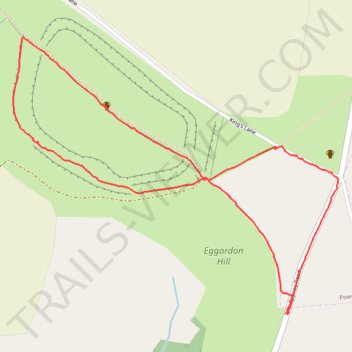
Eggardon Hill Walk
- Distance: 1.6 mi
- Elevation gain: 157 ft
- Maximum elevation: 810 ft
- Elevation loss: 154 ft
- Minimum elevation: 732 ft
- Moving time: 48 m 32 s
- Moving speed: 2.0 mph
- Maximum speed: 4.5 mph
- Total time: 1 h 10 m
- Global speed: 1.4 mph
Interactive trail map
Thank you for supporting this site ❤️
Make a donation
Make a donation
Gear up for your next adventure:
As an Amazon Associate, this site earns from qualifying purchases at no extra cost to you.
Trail profile
- Distance: 1.6 mi
- Elevation gain: 157 ft
- Maximum elevation: 810 ft
- Elevation loss: 154 ft
- Minimum elevation: 732 ft
- Moving time: 48 m 32 s
- Moving speed: 2.0 mph
- Maximum speed: 4.5 mph
- Total time: 1 h 10 m
- Global speed: 1.4 mph
Thank you for supporting this site ❤️
Make a donation
Make a donation
Gear up for your next adventure:
As an Amazon Associate, this site earns from qualifying purchases at no extra cost to you.
About this trail
Name: Eggardon Hill Walk trail, distance, elevation, map, profile, GPS track
Start: Spyway Road, Askerswell, Dorset, England, DT2 9EP, United Kingdom (50.74561 -2.64533)
End: Spyway Road, Askerswell, Dorset, England, DT2 9EP, United Kingdom (50.74559 -2.64526)
Coordinates: 50.74559 -2.65491 50.75178 -2.64344
Thank you for supporting this site ❤️
Make a donation
Make a donation
Gear up for your next adventure:
As an Amazon Associate, this site earns from qualifying purchases at no extra cost to you.