Make a donation
Gear up for your next adventure:
As an Amazon Associate, this site earns from qualifying purchases at no extra cost to you.
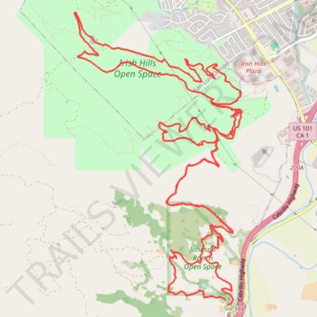
Johnson Ranch Open Space and Irish Hills Open Space loop
- Distance: 15.4 mi
- Elevation gain: 2,497 ft
- Maximum elevation: 856 ft
- Elevation loss: 2,503 ft
- Minimum elevation: 95 ft
- Moving time: 3 h 12 m
- Moving speed: 4.8 mph
- Maximum speed: 21.3 mph
- Total time: 4 h 24 m
- Global speed: 3.5 mph
Interactive trail map
Make a donation
Gear up for your next adventure:
As an Amazon Associate, this site earns from qualifying purchases at no extra cost to you.
Trail profile
- Distance: 15.4 mi
- Elevation gain: 2,497 ft
- Maximum elevation: 856 ft
- Elevation loss: 2,503 ft
- Minimum elevation: 95 ft
- Moving time: 3 h 12 m
- Moving speed: 4.8 mph
- Maximum speed: 21.3 mph
- Total time: 4 h 24 m
- Global speed: 3.5 mph
Make a donation
Gear up for your next adventure:
As an Amazon Associate, this site earns from qualifying purchases at no extra cost to you.
About this trail
Name: Johnson Ranch Open Space and Irish Hills Open Space loop trail, distance, elevation, map, profile, GPS track
Start: Johnson Ranch Loop, San Luis Obispo County, California, 93405, United States (35.22446 -120.69358)
End: Johnson Ranch Loop, San Luis Obispo County, California, 93405, United States (35.22392 -120.69331)
Coordinates: 35.22392 -120.71513 35.25800 -120.69120
Topography: San Luis Obispo County topographic map, elevation, terrain
Make a donation
Gear up for your next adventure:
As an Amazon Associate, this site earns from qualifying purchases at no extra cost to you.