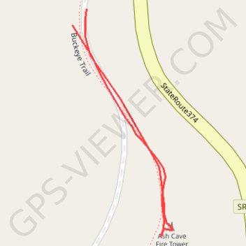
Ash Cave Fire Tower
A Hocking Hills Trail
- Distance: 0.2 mi
- Elevation gain: 26 ft
- Maximum elevation: 1,079 ft
- Elevation loss: 23 ft
- Minimum elevation: 1,060 ft
- Moving time: 5 m 2 s
- Moving speed: 2.6 mph
- Maximum speed: 3.6 mph
- Total time: 14 m 51 s
- Global speed: 0.9 mph
Interactive trail map
Trail profile
- Distance: 0.2 mi
- Elevation gain: 26 ft
- Maximum elevation: 1,079 ft
- Elevation loss: 23 ft
- Minimum elevation: 1,060 ft
- Moving time: 5 m 2 s
- Moving speed: 2.6 mph
- Maximum speed: 3.6 mph
- Total time: 14 m 51 s
- Global speed: 0.9 mph
About this trail
Name: Ash Cave Fire Tower trail, distance, elevation, map, profile, GPS track
Start: Buckeye Trail, Hocking County, Ohio, United States (39.40710 -82.53150)
End: Buckeye Trail, Hocking County, Ohio, United States (39.40720 -82.53139)
Coordinates: 39.40580 -82.53150 39.40720 -82.53070
Topography: Hocking County topographic map, elevation, terrain