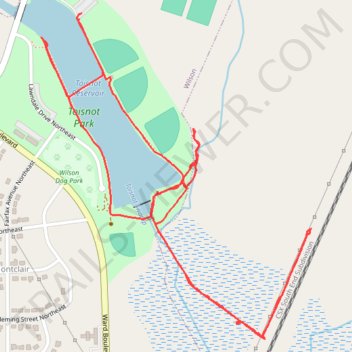
Toisnot Park Loop
- Distance: 2.8 mi
- Elevation gain: 69 ft
- Maximum elevation: 118 ft
- Elevation loss: 69 ft
- Minimum elevation: 95 ft
- Moving time: 57 m 16 s
- Moving speed: 2.9 mph
- Maximum speed: 4.9 mph
- Total time: 59 m 28 s
- Global speed: 2.8 mph
Interactive trail map
Trail profile
- Distance: 2.8 mi
- Elevation gain: 69 ft
- Maximum elevation: 118 ft
- Elevation loss: 69 ft
- Minimum elevation: 95 ft
- Moving time: 57 m 16 s
- Moving speed: 2.9 mph
- Maximum speed: 4.9 mph
- Total time: 59 m 28 s
- Global speed: 2.8 mph
About this trail
Name: Toisnot Park Loop trail, distance, elevation, map, profile, GPS track
Start: Fike Cross Country Course, Wilson, Wilson County, North Carolina, United States (35.74896 -77.90414)
End: Fike Cross Country Course, Wilson, Wilson County, North Carolina, United States (35.74881 -77.90423)
Coordinates: 35.74058 -77.90542 35.74896 -77.89687
Topography: Wilson topographic map, elevation, terrain