Thank you for supporting this site ❤️
Make a donation
Make a donation
Gear up for your next adventure:
As an Amazon Associate, this site earns from qualifying purchases at no extra cost to you.
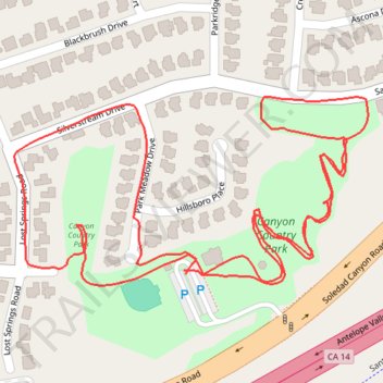
Canyon Country Park loop walk
- Distance: 1.6 mi
- Elevation gain: 174 ft
- Maximum elevation: 1,604 ft
- Elevation loss: 174 ft
- Minimum elevation: 1,483 ft
- Moving time: 36 m 35 s
- Moving speed: 2.6 mph
- Maximum speed: 4.3 mph
- Total time: 43 m 3 s
- Global speed: 2.2 mph
Interactive trail map
Thank you for supporting this site ❤️
Make a donation
Make a donation
Gear up for your next adventure:
As an Amazon Associate, this site earns from qualifying purchases at no extra cost to you.
Trail profile
- Distance: 1.6 mi
- Elevation gain: 174 ft
- Maximum elevation: 1,604 ft
- Elevation loss: 174 ft
- Minimum elevation: 1,483 ft
- Moving time: 36 m 35 s
- Moving speed: 2.6 mph
- Maximum speed: 4.3 mph
- Total time: 43 m 3 s
- Global speed: 2.2 mph
Thank you for supporting this site ❤️
Make a donation
Make a donation
Gear up for your next adventure:
As an Amazon Associate, this site earns from qualifying purchases at no extra cost to you.
About this trail
Name: Canyon Country Park loop walk trail, distance, elevation, map, profile, GPS track
Coordinates: 34.41838 -118.44449 34.42057 -118.43952
Topography: Santa Clarita topographic map, elevation, terrain
Thank you for supporting this site ❤️
Make a donation
Make a donation
Gear up for your next adventure:
As an Amazon Associate, this site earns from qualifying purchases at no extra cost to you.