Thank you for supporting this site ❤️
Make a donation
Make a donation
Gear up for your next adventure:
As an Amazon Associate, this site earns from qualifying purchases at no extra cost to you.
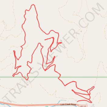
Mountain Bike Loop Ride in Lolo National Forest
- Distance: 11.4 mi
- Elevation gain: 2,612 ft
- Maximum elevation: 5,131 ft
- Elevation loss: 2,549 ft
- Minimum elevation: 3,448 ft
- Moving time: 1 h 53 m
- Moving speed: 6.1 mph
- Maximum speed: 27.1 mph
- Total time: 2 h 19 m
- Global speed: 4.9 mph
Interactive trail map
Thank you for supporting this site ❤️
Make a donation
Make a donation
Gear up for your next adventure:
As an Amazon Associate, this site earns from qualifying purchases at no extra cost to you.
Trail profile
- Distance: 11.4 mi
- Elevation gain: 2,612 ft
- Maximum elevation: 5,131 ft
- Elevation loss: 2,549 ft
- Minimum elevation: 3,448 ft
- Moving time: 1 h 53 m
- Moving speed: 6.1 mph
- Maximum speed: 27.1 mph
- Total time: 2 h 19 m
- Global speed: 4.9 mph
Thank you for supporting this site ❤️
Make a donation
Make a donation
Gear up for your next adventure:
As an Amazon Associate, this site earns from qualifying purchases at no extra cost to you.
About this trail
Name: Mountain Bike Loop Ride in Lolo National Forest trail, distance, elevation, map, profile, GPS track
Start: Missoula County, Montana, 59847, United States (46.75535 -114.21145)
End: Missoula County, Montana, 59847, United States (46.75535 -114.20708)
Coordinates: 46.75510 -114.23591 46.78075 -114.20504
Topography: Missoula County topographic map, elevation, terrain
Thank you for supporting this site ❤️
Make a donation
Make a donation
Gear up for your next adventure:
As an Amazon Associate, this site earns from qualifying purchases at no extra cost to you.