Make a donation
Gear up for your next adventure:
As an Amazon Associate, this site earns from qualifying purchases at no extra cost to you.
Akrabim and Tzafir
עקרבים וצפיר: על התפר שבין הנגב לערבה: מעלה עקרבים ומעלה צפיר
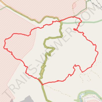
- Distance: 11.4 mi
- Elevation gain: 2,208 ft
- Maximum elevation: 1,709 ft
- Elevation loss: 2,205 ft
- Minimum elevation: 82 ft
- Moving time: 5 h 34 m
- Moving speed: 2.0 mph
- Maximum speed: 2.5 mph
- Total time: 5 h 34 m
- Global speed: 2.0 mph
Interactive trail map
Make a donation
Gear up for your next adventure:
As an Amazon Associate, this site earns from qualifying purchases at no extra cost to you.
Trail profile
- Distance: 11.4 mi
- Elevation gain: 2,208 ft
- Maximum elevation: 1,709 ft
- Elevation loss: 2,205 ft
- Minimum elevation: 82 ft
- Moving time: 5 h 34 m
- Moving speed: 2.0 mph
- Maximum speed: 2.5 mph
- Total time: 5 h 34 m
- Global speed: 2.0 mph
Make a donation
Gear up for your next adventure:
As an Amazon Associate, this site earns from qualifying purchases at no extra cost to you.
About this trail
Name: Akrabim and Tzafir trail, distance, elevation, map, profile, GPS track
Coordinates: 30.89941 35.10836 30.93482 35.16547
Make a donation
Gear up for your next adventure:
As an Amazon Associate, this site earns from qualifying purchases at no extra cost to you.
Other hiking, mountain biking, running and outdoor activity trails
Click on a trail to view its statistics, map and profile.
Half loop around the Small Crater
Israel > South District > Tamar Regional Council
חצי סובב המכתש הקטן: שער אשמדאי, מעלה עלי ונחל מצלעות
Distance: 13.8 mi • Elevation gain: 2,828 ft • Maximum elevation: 1,654 ft
Ein Yorkeam - Tzafir
Israel > South District > Ramat Negev Regional Council
עין ירקעם ומיצד צפיר: נחל חתירה, מעלה ימין וגב ימין
Distance: 12.3 mi • Elevation gain: 1,877 ft • Maximum elevation: 1,565 ft