Make a donation
Gear up for your next adventure:
As an Amazon Associate, this site earns from qualifying purchases at no extra cost to you.
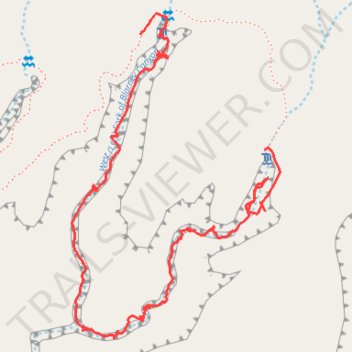
Blarney Canyon - Hiking / canyoning
- Distance: 1.3 mi
- Elevation gain: 305 ft
- Maximum elevation: 4,911 ft
- Elevation loss: 292 ft
- Minimum elevation: 4,626 ft
- Moving time: 48 m 51 s
- Moving speed: 1.6 mph
- Maximum speed: 4.9 mph
- Total time: 2 h 34 m
- Global speed: 0.5 mph
Interactive trail map
Make a donation
Gear up for your next adventure:
As an Amazon Associate, this site earns from qualifying purchases at no extra cost to you.
Trail profile
- Distance: 1.3 mi
- Elevation gain: 305 ft
- Maximum elevation: 4,911 ft
- Elevation loss: 292 ft
- Minimum elevation: 4,626 ft
- Moving time: 48 m 51 s
- Moving speed: 1.6 mph
- Maximum speed: 4.9 mph
- Total time: 2 h 34 m
- Global speed: 0.5 mph
Make a donation
Gear up for your next adventure:
As an Amazon Associate, this site earns from qualifying purchases at no extra cost to you.
About this trail
Name: Blarney Canyon - Hiking / canyoning trail, distance, elevation, map, profile, GPS track
Start: Blarney Canyon Approach, Garfield County, Utah, United States (38.03377 -110.53922)
End: Blarney Canyon Approach, Garfield County, Utah, United States (38.03164 -110.53632)
Coordinates: 38.02816 -110.54084 38.03416 -110.53597
Topography: Garfield County topographic map, elevation, terrain
Make a donation
Gear up for your next adventure:
As an Amazon Associate, this site earns from qualifying purchases at no extra cost to you.
Other hiking, mountain biking, running and outdoor activity trails
Click on a trail to view its statistics, map and profile.
West Fork Leprechaun Canyon Approach
United States > Utah > Garfield County
Distance: 1.6 mi • Elevation gain: 561 ft • Maximum elevation: 4,987 ft