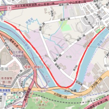
Thank you for supporting this site ❤️
Make a donation
Make a donation
Gear up for your next adventure:
As an Amazon Associate, this site earns from qualifying purchases at no extra cost to you.
Run at river side
Round-trip.
- Distance: 3.2 mi
- Elevation gain: 98 ft
- Maximum elevation: 56 ft
- Elevation loss: 102 ft
- Minimum elevation: 20 ft
- Moving time: 36 m 20 s
- Moving speed: 5.2 mph
- Maximum speed: 7.1 mph
- Total time: 37 m 30 s
- Global speed: 5.0 mph
Interactive trail map
Thank you for supporting this site ❤️
Make a donation
Make a donation
Gear up for your next adventure:
As an Amazon Associate, this site earns from qualifying purchases at no extra cost to you.
Trail profile
- Distance: 3.2 mi
- Elevation gain: 98 ft
- Maximum elevation: 56 ft
- Elevation loss: 102 ft
- Minimum elevation: 20 ft
- Moving time: 36 m 20 s
- Moving speed: 5.2 mph
- Maximum speed: 7.1 mph
- Total time: 37 m 30 s
- Global speed: 5.0 mph
Thank you for supporting this site ❤️
Make a donation
Make a donation
Gear up for your next adventure:
As an Amazon Associate, this site earns from qualifying purchases at no extra cost to you.
About this trail
Name: Run at river side trail, distance, elevation, map, profile, GPS track
Coordinates: 25.05506 121.61777 25.06427 121.63309
Thank you for supporting this site ❤️
Make a donation
Make a donation
Gear up for your next adventure:
As an Amazon Associate, this site earns from qualifying purchases at no extra cost to you.