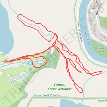
Pioneer Dairy parkrun
- Distance: 3.2 mi
- Elevation gain: 39 ft
- Maximum elevation: 20 ft
- Elevation loss: 39 ft
- Minimum elevation: 7 ft
- Moving time: 22 m 38 s
- Moving speed: 8.6 mph
- Maximum speed: 15.3 mph
- Total time: 22 m 38 s
- Global speed: 8.6 mph
Interactive trail map
Trail profile
- Distance: 3.2 mi
- Elevation gain: 39 ft
- Maximum elevation: 20 ft
- Elevation loss: 39 ft
- Minimum elevation: 7 ft
- Moving time: 22 m 38 s
- Moving speed: 8.6 mph
- Maximum speed: 15.3 mph
- Total time: 22 m 38 s
- Global speed: 8.6 mph
About this trail
Name: Pioneer Dairy parkrun trail, distance, elevation, map, profile, GPS track
Coordinates: -33.30056 151.42705 -33.29455 151.43616
Other hiking, mountain biking, running and outdoor activity trails
Click on a trail to view its statistics, map and profile.
Tuggerawong Pathway from Wyong
Australia > New South Wales > Wyong
Distance: 11.8 mi • Elevation gain: 390 ft • Maximum elevation: 95 ft