Thank you for supporting this site ❤️
Make a donation
Make a donation
Gear up for your next adventure:
As an Amazon Associate, this site earns from qualifying purchases at no extra cost to you.
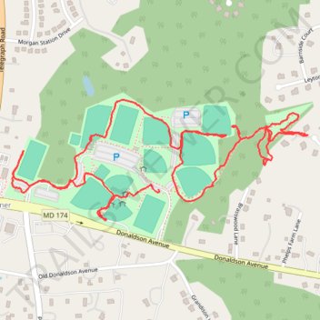
Severn-Danza Park
- Distance: 2.3 mi
- Elevation gain: 69 ft
- Maximum elevation: 190 ft
- Elevation loss: 49 ft
- Minimum elevation: 151 ft
- Moving time: 1 h 3 m
- Moving speed: 2.1 mph
- Maximum speed: 9.1 mph
- Total time: 1 h 13 m
- Global speed: 1.9 mph
Interactive trail map
Thank you for supporting this site ❤️
Make a donation
Make a donation
Gear up for your next adventure:
As an Amazon Associate, this site earns from qualifying purchases at no extra cost to you.
Trail profile
- Distance: 2.3 mi
- Elevation gain: 69 ft
- Maximum elevation: 190 ft
- Elevation loss: 49 ft
- Minimum elevation: 151 ft
- Moving time: 1 h 3 m
- Moving speed: 2.1 mph
- Maximum speed: 9.1 mph
- Total time: 1 h 13 m
- Global speed: 1.9 mph
Thank you for supporting this site ❤️
Make a donation
Make a donation
Gear up for your next adventure:
As an Amazon Associate, this site earns from qualifying purchases at no extra cost to you.
About this trail
Name: Severn-Danza Park trail, distance, elevation, map, profile, GPS track
Coordinates: 39.13607 -76.68457 39.13932 -76.67428
Topography: Anne Arundel County topographic map, elevation, terrain
Thank you for supporting this site ❤️
Make a donation
Make a donation
Gear up for your next adventure:
As an Amazon Associate, this site earns from qualifying purchases at no extra cost to you.