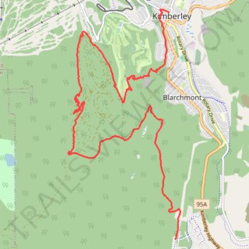
Bike trail near Kimberley
- Distance: 9.8 mi
- Elevation gain: 1,480 ft
- Maximum elevation: 4,531 ft
- Elevation loss: 1,175 ft
- Minimum elevation: 3,376 ft
- Moving time: 1 h 47 m
- Moving speed: 5.5 mph
- Maximum speed: 17.5 mph
- Total time: 2 h 2 m
- Global speed: 4.8 mph
Interactive trail map
Trail profile
- Distance: 9.8 mi
- Elevation gain: 1,480 ft
- Maximum elevation: 4,531 ft
- Elevation loss: 1,175 ft
- Minimum elevation: 3,376 ft
- Moving time: 1 h 47 m
- Moving speed: 5.5 mph
- Maximum speed: 17.5 mph
- Total time: 2 h 2 m
- Global speed: 4.8 mph
About this trail
Name: Bike trail near Kimberley trail, distance, elevation, map, profile, GPS track
Coordinates: 49.64293 -116.01205 49.68625 -115.97934
Other hiking, mountain biking, running and outdoor activity trails
Click on a trail to view its statistics, map and profile.
Mcginty Lake Loop
Canada > British Columbia > Regional District of East Kootenay > Kimberley
Distance: 24.3 mi • Elevation gain: 1,286 ft • Maximum elevation: 3,704 ft
Dipper Lake/Horsebarn Nature Park Trail
Canada > British Columbia > Regional District of East Kootenay > Kimberley
Bike, trails, kimberley
Distance: 11.8 mi • Elevation gain: 1,896 ft • Maximum elevation: 4,403 ft
Rails to Trails
Canada > British Columbia > Regional District of East Kootenay > Kimberley
Bike, Trails, Kimberley
Distance: 12.1 mi • Elevation gain: 810 ft • Maximum elevation: 3,409 ft
Bike Trails in Kimberley
Canada > British Columbia > Regional District of East Kootenay > Kimberley
Tour through the forest
Distance: 7.7 mi • Elevation gain: 991 ft • Maximum elevation: 4,029 ft
Mountain Bike trail near Kimberley
Canada > British Columbia > Regional District of East Kootenay > Kimberley
Distance: 15.8 mi • Elevation gain: 2,208 ft • Maximum elevation: 3,786 ft
Bike trail near Kimberley
Canada > British Columbia > Regional District of East Kootenay > Kimberley
Bike, trails, kimberley
Distance: 6.7 mi • Elevation gain: 682 ft • Maximum elevation: 3,806 ft
Round the North Star Mountain
Canada > British Columbia > Regional District of East Kootenay > Kimberley
Distance: 12.5 mi • Elevation gain: 1,926 ft • Maximum elevation: 5,292 ft
Bike Trails in Kimberley
Canada > British Columbia > Regional District of East Kootenay > Kimberley
Bike, Trails, Kimberley
Distance: 13.3 mi • Elevation gain: 1,818 ft • Maximum elevation: 4,475 ft
Marks Creek trail
Canada > British Columbia > Regional District of East Kootenay > Kimberley
Little ride in the afternoon
Distance: 8.0 mi • Elevation gain: 666 ft • Maximum elevation: 3,491 ft