Thank you for supporting this site ❤️
Make a donation
Make a donation
Gear up for your next adventure:
As an Amazon Associate, this site earns from qualifying purchases at no extra cost to you.
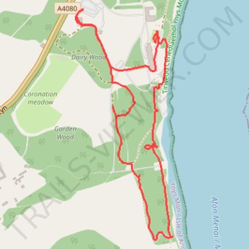
Walking around Plas Newydd, Ynys Môn
- Distance: 2.2 mi
- Elevation gain: 262 ft
- Maximum elevation: 135 ft
- Elevation loss: 262 ft
- Minimum elevation: 10 ft
- Moving time: 1 h 8 m
- Moving speed: 1.9 mph
- Maximum speed: 3.0 mph
- Total time: 1 h 54 m
- Global speed: 1.1 mph
Interactive trail map
Thank you for supporting this site ❤️
Make a donation
Make a donation
Gear up for your next adventure:
As an Amazon Associate, this site earns from qualifying purchases at no extra cost to you.
Trail profile
- Distance: 2.2 mi
- Elevation gain: 262 ft
- Maximum elevation: 135 ft
- Elevation loss: 262 ft
- Minimum elevation: 10 ft
- Moving time: 1 h 8 m
- Moving speed: 1.9 mph
- Maximum speed: 3.0 mph
- Total time: 1 h 54 m
- Global speed: 1.1 mph
Thank you for supporting this site ❤️
Make a donation
Make a donation
Gear up for your next adventure:
As an Amazon Associate, this site earns from qualifying purchases at no extra cost to you.
About this trail
Name: Walking around Plas Newydd, Ynys Môn trail, distance, elevation, map, profile, GPS track
Coordinates: 53.19578 -4.22085 53.20456 -4.21464
Thank you for supporting this site ❤️
Make a donation
Make a donation
Gear up for your next adventure:
As an Amazon Associate, this site earns from qualifying purchases at no extra cost to you.