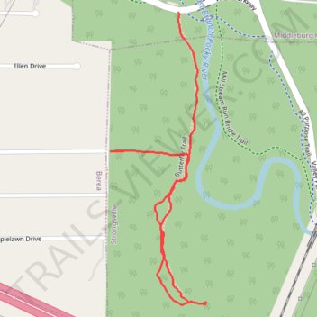
Butterfly Trail
- Distance: 1.0 mi
- Elevation gain: 69 ft
- Maximum elevation: 840 ft
- Elevation loss: 30 ft
- Minimum elevation: 791 ft
- Moving time: 19 m 57 s
- Moving speed: 3.0 mph
- Maximum speed: 5.2 mph
- Total time: 19 m 57 s
- Global speed: 3.0 mph
Interactive trail map
Trail profile
- Distance: 1.0 mi
- Elevation gain: 69 ft
- Maximum elevation: 840 ft
- Elevation loss: 30 ft
- Minimum elevation: 791 ft
- Moving time: 19 m 57 s
- Moving speed: 3.0 mph
- Maximum speed: 5.2 mph
- Total time: 19 m 57 s
- Global speed: 3.0 mph
About this trail
Name: Butterfly Trail trail, distance, elevation, map, profile, GPS track
Start: Valley Parkway, Middleburg Heights, Cuyahoga County, Ohio, 44017, United States (41.35129 -81.84650)
End: 236, Dorland Avenue, Berea, Cuyahoga County, Ohio, 44017, United States (41.34819 -81.84802)
Coordinates: 41.34475 -81.84852 41.35129 -81.84566
Topography: Cuyahoga County topographic map, elevation, terrain