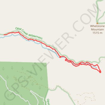
Opal Creek
Loop hike to the Opal Creek along Little North Santiam River via Sawmill Falls, Opal Pool and Kopetski Trail in the Opal Creek Wilderness. #Hiking #Loop #Nature #River #Forest #Falls #Mountain #Wilderness
- Distance: 5.8 mi
- Elevation gain: 1,480 ft
- Maximum elevation: 2,201 ft
- Elevation loss: 1,450 ft
- Minimum elevation: 1,860 ft
- Moving time: 2 h 57 m
- Moving speed: 2.0 mph
- Maximum speed: 3.4 mph
- Total time: 5 h 10 m
- Global speed: 1.1 mph
Interactive trail map
Trail profile
- Distance: 5.8 mi
- Elevation gain: 1,480 ft
- Maximum elevation: 2,201 ft
- Elevation loss: 1,450 ft
- Minimum elevation: 1,860 ft
- Moving time: 2 h 57 m
- Moving speed: 2.0 mph
- Maximum speed: 3.4 mph
- Total time: 5 h 10 m
- Global speed: 1.1 mph
About this trail
Name: Opal Creek trail, distance, elevation, map, profile, GPS track
Start: Forest Road 2209, Marion County, Oregon, United States (44.85988 -122.26435)
End: Kopetski Trail, Marion County, Oregon, United States (44.84940 -122.22636)
Coordinates: 44.84364 -122.26435 44.86105 -122.20565
Topography: Marion County topographic map, elevation, terrain