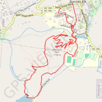
Wildcat Lake and Hemlock Hill Loop
Loop hike from Banner Elk to Wildcat Lake via Lees-McRae College, Mill Pond and Hemlock Hill. #Hiking #Loop #Nature #Forest #Lake
- Distance: 4.7 mi
- Elevation gain: 686 ft
- Maximum elevation: 3,871 ft
- Elevation loss: 696 ft
- Minimum elevation: 3,635 ft
- Moving time: 1 h 47 m
- Moving speed: 2.6 mph
- Maximum speed: 4.1 mph
- Total time: 2 h 9 m
- Global speed: 2.2 mph
Interactive trail map
Trail profile
- Distance: 4.7 mi
- Elevation gain: 686 ft
- Maximum elevation: 3,871 ft
- Elevation loss: 696 ft
- Minimum elevation: 3,635 ft
- Moving time: 1 h 47 m
- Moving speed: 2.6 mph
- Maximum speed: 4.1 mph
- Total time: 2 h 9 m
- Global speed: 2.2 mph
About this trail
Name: Wildcat Lake and Hemlock Hill Loop trail, distance, elevation, map, profile, GPS track
Coordinates: 36.14833 -81.88222 36.16300 -81.87197
Topography: Avery County topographic map, elevation, terrain