Thank you for supporting this site ❤️
Make a donation
Make a donation
Gear up for your next adventure:
As an Amazon Associate, this site earns from qualifying purchases at no extra cost to you.
Sagamook Mountain - Mount Carleton
Interactive trail map
Thank you for supporting this site ❤️
Make a donation
Make a donation
Gear up for your next adventure:
As an Amazon Associate, this site earns from qualifying purchases at no extra cost to you.
Trail profile
- Distance: 9.5 mi
- Elevation gain: 2,687 ft
- Maximum elevation: 2,608 ft
- Elevation loss: 2,687 ft
- Minimum elevation: 928 ft
Thank you for supporting this site ❤️
Make a donation
Make a donation
Gear up for your next adventure:
As an Amazon Associate, this site earns from qualifying purchases at no extra cost to you.
About this trail
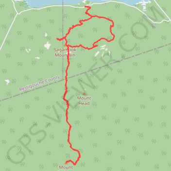
Name: Sagamook Mountain - Mount Carleton trail, distance, elevation, map, profile, GPS track
Start: Addington Parish, Restigouche County, New Brunswick, Canada (47.41827 -66.86865)
End: Addington Parish, Restigouche County, New Brunswick, Canada (47.41830 -66.86859)
Coordinates: 47.37744 -66.87939 47.41832 -66.85744
Thank you for supporting this site ❤️
Make a donation
Make a donation
Gear up for your next adventure:
As an Amazon Associate, this site earns from qualifying purchases at no extra cost to you.
Other hiking, mountain biking, running and outdoor activity trails
Click on a trail to view its statistics, map and profile.