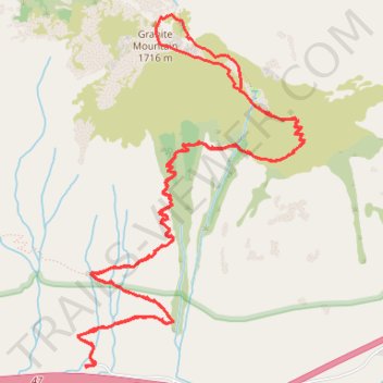
Granite Mountain Trail in Alpine Lakes Wilderness
- Distance: 8.5 mi
- Elevation gain: 3,855 ft
- Maximum elevation: 5,558 ft
- Elevation loss: 3,845 ft
- Minimum elevation: 1,857 ft
- Moving time: 5 h 26 m
- Moving speed: 1.6 mph
- Maximum speed: 6.5 mph
- Total time: 7 h 31 m
- Global speed: 1.1 mph
Interactive trail map
Trail profile
- Distance: 8.5 mi
- Elevation gain: 3,855 ft
- Maximum elevation: 5,558 ft
- Elevation loss: 3,845 ft
- Minimum elevation: 1,857 ft
- Moving time: 5 h 26 m
- Moving speed: 1.6 mph
- Maximum speed: 6.5 mph
- Total time: 7 h 31 m
- Global speed: 1.1 mph
About this trail
Name: Granite Mountain Trail in Alpine Lakes Wilderness trail, distance, elevation, map, profile, GPS track
End: Pratt Lake Trail, King County, Washington, 98068, United States (47.39787 -121.48644)
Coordinates: 47.39757 -121.48801 47.41817 -121.46842
Topography: King County topographic map, elevation, terrain
Other hiking, mountain biking, running and outdoor activity trails
Click on a trail to view its statistics, map and profile.
Franklin Falls via Denny Creek Road and Franklin Falls Trail
United States > Washington > King County > Rockdale
The Franklin Falls Trail is an enjoyable and scenic hike through the lush forests of the Mount Baker-Snoqualmie National Forest. As you make your way along the trail, you'll pass towering pines, moss-covered boulders, and the sounds of the South Fork Snoqualmie River, which provides a peaceful backdrop. The…
Distance: 8.6 mi • Elevation gain: 1,289 ft • Maximum elevation: 2,644 ft
Granite Mountain Trail in Mount Baker Snoqualmie National Forest
United States > Washington > King County
The Granite Mountain Trail, located near Snoqualmie Pass in Washington’s Mount Baker-Snoqualmie National Forest, offers an exhilarating hiking experience with remarkable views. As you ascend, you’ll pass through a lush forest before reaching exposed rocky meadows and the fire lookout that provide stunning…
Distance: 8.0 mi • Elevation gain: 3,760 ft • Maximum elevation: 5,561 ft
Melakwa Lake via Denny Creek Trail in Alpine Lakes Wilderness
United States > Washington > King County
The Melakwa Lake via Denny Creek Trail offers a captivating journey through the Alpine Lakes Wilderness. The route begins in lush forested areas, where hikers can enjoy views of cascading waterfalls, including the dramatic Keekwulee Falls, before ascending to rocky and open terrain. The trail culminates at…
Distance: 8.7 mi • Elevation gain: 2,838 ft • Maximum elevation: 4,649 ft
Northern part of the Pacific Crest Trail (PCT)
United States > Oregon > Klamath County
Hike on the Pacific Crest National Scenic Trail from Crater Lake to Canada Border through Oregon and Washington along the Sierra Nevada and Cascade mountain ranges. #Hiking #Mountain #SierraNevada #Cascade #Nature #Forest #Park #PCT
Distance: 744.6 mi • Elevation gain: 145,367 ft • Maximum elevation: 7,569 ft