Thank you for supporting this site ❤️
Make a donation
Make a donation
Gear up for your next adventure:
As an Amazon Associate, this site earns from qualifying purchases at no extra cost to you.
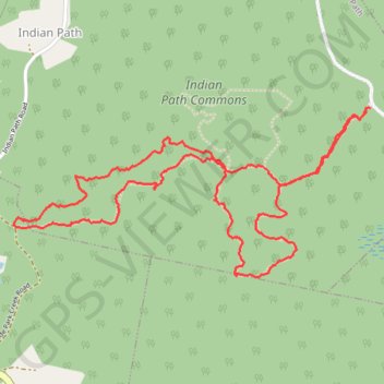
Indian Path Trail
#Hiking #Wilderness #Backcountry
- Distance: 3.3 mi
- Elevation gain: 295 ft
- Maximum elevation: 210 ft
- Elevation loss: 295 ft
- Minimum elevation: 26 ft
- Moving time: 1 h 29 m
- Moving speed: 2.2 mph
- Maximum speed: 4.5 mph
- Total time: 2 h 6 m
- Global speed: 1.6 mph
Interactive trail map
Thank you for supporting this site ❤️
Make a donation
Make a donation
Gear up for your next adventure:
As an Amazon Associate, this site earns from qualifying purchases at no extra cost to you.
Trail profile
- Distance: 3.3 mi
- Elevation gain: 295 ft
- Maximum elevation: 210 ft
- Elevation loss: 295 ft
- Minimum elevation: 26 ft
- Moving time: 1 h 29 m
- Moving speed: 2.2 mph
- Maximum speed: 4.5 mph
- Total time: 2 h 6 m
- Global speed: 1.6 mph
Thank you for supporting this site ❤️
Make a donation
Make a donation
Gear up for your next adventure:
As an Amazon Associate, this site earns from qualifying purchases at no extra cost to you.
About this trail
Name: Indian Path Trail trail, distance, elevation, map, profile, GPS track
Coordinates: 44.30660 -64.34323 44.31275 -64.32519
Thank you for supporting this site ❤️
Make a donation
Make a donation
Gear up for your next adventure:
As an Amazon Associate, this site earns from qualifying purchases at no extra cost to you.